Monday, October 25, 2021

Allegheny Mountains Loop, Day 8


Day 8: 10/22; 43.8 miles, back to Blacksburg; 4,253 feet of climbing; TM: 360.6; TC: 22,182.


The climb from White Rocks up to Mountain Lake Lodge was on steep and sustained gravel.


The first thing we noticed as we arrived at Mountain Lake was that there was, uh, almost no water in there. It’s basically a big crater. What little water remains looks more like a large mud puddle than a lake. 


Apparently, the water drains from holes in the lake’s bottom. When the amount of water draining out exceeds the amount flowing in, the lake’s water level goes down.


Thus the lodge has shifted its focus over the years from promoting itself as a vacation spot for swimming and boating to a location for such activities as zip-lining, hiking, archery and bubble ball.


The lodge also heavily promotes the fact that some of the scenes from the 1987 film “Dirty Dancing” were shot here and holds some events that are tied to the movie.


The lodge’s restaurant is first-rate, however, and not too pricy. Well worth a visit.


Hoping to cut off a few miles from today’s route, Dave suggested that we consider a shortcut via U.S. 460 back to Blacksburg.


But a Virginia Tech alum I met at the lodge said there was little shoulder and lots of truck traffic on the highway.


In its official Allegheny Mountains Loop route map, ACA warns riders to avoid the “busy divided highway with no shoulders.“


“Due to heavy traffic don’t ride more of U.S. 460 as a shortcut unless absolutely necessary,” the association map adds.


I wanted to complete the official route anyway. So I’m glad we agreed to avoid the highway.


Turned out that the official route from Mountain Lake to Blacksburg was the loop’s most scenic for me, and the route went downhill most of the way from lodge back to the New River.


When we got back to Ed’s house, he and his wife Jerri had pizza and a cake awaiting us.


What a great way to end another terrific adventure in the saddle.


Mountain Lake Lodge dining room

Back in Blacksburg


Allegheny Mountains Loop, Day 7


 Day 7: 10/21; 26.6 miles to White Rocks Campground; 2,587 feet of climbing; TM: 316.8; TC: 17,919.


Short but hard day with more challenging hills to White Rocks Campground.


Stopped at a terrific Amish bakery in Gap Mills, WV, Cheese N Things, where I purchased two turkey-and-Swiss sandwiches on freshly-baked whole-wheat bread. Ate one sandwich there, and saved the other for later. Best sandwiches ever.


When we arrived at the White Rocks campground at 4 pm, we were once again the only campers.


It was good that we had filled up our water bottles in the stream a half mile below, because the campground’s tap water and bathrooms were out of commission.


(There were a couple of portapotties in the campground, and I later found a small spring.)


I was feeling drained today, so I went to sleep at 6:30 pm, after a cold dinner of canned sardines, canned beans and canned peaches.


I woke up briefly when it started raining that night but fell back to sleep shortly thereafter and didn’t get up until 7 am.


11.5 hours of sleep. Not bad. Like a baby. Eat, sleep, ride.


For more trip details and photos, please see Allegheny Mountains Loop, Day 8.


Dave on the porch, Cheese N Things

Doug with Cheese N Things sandwich

Filtering stream water


White Rocks campground


Allegheny Mountains Loop, Day 6

Moncove Lake

Day 6: 10/20; 52.3 miles to Moncove Lake State Park; 2,677 feet of climbing; TM: 290.2; TC: 15,342.


The first part of today’s ride, over the final 33 miles of the Greenbrier River Trail, was easy.


But after the trail ended near North Caldwell, the route shifted onto pavement, and soon we were back into serious hill-climbing. For several miles, we were also back into traffic on the poorly-shouldered Hwy 60.


We took a lunch break at a McDonald’s restaurant near the intersection of Hwy 60 and Interstate 64.


After lunch, we continued climbing on a lightly-trafficked series of rural backroads up toward Moncove Lake.


Over the past week, plenty of dogs had barked at us as we passed by on our bikes.  But until now, all had been either fenced in, tied down or gave up the chase at their owner’s property lines.


Shortly before we reached Moncove Lake, however, we noticed a large German Shepherd checking us out from the middle of the rural road ahead. The dog’s owner was nowhere to be seen. In fact, there was nobody else around. It was Dave and me and the dog in the middle of a rough, rural road, and a showdown was in the cards.


As we approached on our bikes, the beast retreated. He was skittish, possibly intimidated. Good.


I told the dog to go home, and he walked away, up the road and then up a driveway toward a trailer.


But after Dave passed, the dog began growling again and circled back around behind me, positioning himself to give chase.


I stopped, grabbed my can of Halt dog repellent spray and performed the dog-whispering routine I had learned from my ex-father-in-law, a hard-as-nails Missouri farmer.


“Get home you son-of-a-bitch!” I hollered, putting all the alpha-male menace I could muster into it.


The startled dog stopped in its tracks, no longer so cocksure of itself, and it retreated, cowering, back into its owner’s yard.


Bravo! Fooled another one. Another round to the Dog Whisperer! And I rode on.


My other dog trick, which I was performing at the same time I was doing my tough-guy routine, is to point my can of pepper spray in a hostile dog’s direction. Sometimes that’s enough to stop the dog.


My theory is that this may only work with dogs that have been sprayed previously. One taste of that stuff is probably enough.


At any rate, after many years of lugging pepper spray around on my tours, I have yet to actually deploy it. Pointing the can and/or doing the alpha-male routine have done the job thus far. Hopefully, the spray will work if ever needed, not just dribble into a puddle at my feet or backfire.


Moncove Lake was beautiful, and the hot shower at the park was simply divine.


Unfortunately, on my way back to the campsite from the bathroom, I stepped into a hole covered by leaves in the dark and bruised and cut my right knee. Alas, I discovered that I had forgotten to pack my first-aid kit. But I found a couple of band-aids in my toilet kit, and those staunched the bleeding.


My knee was sore and stiff for the rest of the tour but fortunately nothing was broken.


Again, we were the only campers in the tent sites in this campground.


For more trip details and photos, please see Allegheny Mountains Loop, Day 7.


Our campsite, Moncove Lake State Park


Allegheny Mountains Loop, Day 5


 Day 5: 10/19; 51.4 miles to Greenbrier River Trail campsite at MP 33.8; 998 feet of climbing; TM: 237.9; 12,655.


When we awoke at 7 am as usual, the temperature was in the low to mid-30s.


So we headed 2.5 north back to Cass to get a hot breakfast at the Last Run.


We both got the Railroad Special. Mine came with two eggs, two strips of bacon, two sausage patties, two pancakes, and a biscuit with gravy. I also bought a large cinnamon roll for a snack later on. No wonder I sometimes put on weight during these epic bike tours.


Dave working on the Railroad Special

After breakfast, it warmed up into the 70s as we rolled south on the trail, and we both enjoyed the easy pedaling for a change.


In the the all-services trailside town of Marlinton, we stopped for lunch at a Subway, where I overheard the two gentlemen in line ahead of me discussing the Covid infections they had recovered from. Another fellow they greeted in the restaurant apparently also had a relative who had recently recovered from the disease.


I washed my hands thoroughly with antibacterial hand cleanser after I paid for my meal and exited the restaurant.


As Dave and I were eating our sandwiches at a rickety picnic table on the bank of the Greenbrier River across the road from the Subway, we saw two river otters cavorting in the water. This is the first time I’ve seen a river otter in the wild. Cute.


After we had ridden a few more miles south on the trail, Dave stopped to swim in the river while I continued on toward campsite at MP 33.8.


Neither of us had showered since Friday—five days previously. But I decided to put off bathing until I could take a hot shower tomorrow at Moncove State Park, where we had a reservation.


It was a good thing I skipped the swim. I got the better of the two sites at MP 33.8, shortly before a party of three other touring seniors arrived and claimed the other site.


There was a picnic table, a vault toilet and a wooden shelter at the site, but no potable water. So I spent the last half hour or so before sundown filtering water for dinner and breakfast.


For more trip details and photos, please see Allegheny Mountains Loop, Day 6.


Our campsite at MP 33.8


Allegheny Mountains Loop. Day 4


Dave at Lake Moomaw

Day 4: 10/18; 56.5 miles to campsite at milepost 78.5 on the Greenbrier River Trail south of Cass, VA; 4,702 feet of climbing; TM: 186.5; TC: 11,677.


When we awoke at sunrise today, our tents were soaked with dew, and digging a cathole was my first order of business since bathrooms were not available.


When we headed down to the lake to refill our water bottles, we received a nasty surprise: The path to Lake Moomaw was a jungle of sticker and burr weeds.


I was particularly inconvenienced because the wool socks I was wearing with my sandals proved to be a magnet for the stickers.


One of my wool socks with stickers

Thankfully, I had a spare pair of socks to change into, because removing the stickers proved to be a formidable and time-consuming challenge.


The first 30 miles of today’s ride proved to be relatively easy. But the 3.5-mile climb up the Dunmore cutoff to Cass, though never overly steep, was mind-numbingly tedious and came with just enough traffic to keep us on edge.


For dinner that night at the Last Run restaurant in Cass, I had the spaghetti and Dave had the fried chicken. I am speculating that the spaghetti was just the sauce for the night’s Sloppy Joe special slathered over a bed of flaccid pasta. It was OK, though. Good energy food.


The town sheriff moseyed by as I was picking stickers out of my socks while waiting for the food outside the restaurant. He was a nice guy and offered good advice about where to camp on the trail.


Somebody had left a stack of split firewood at our  campsite for the night at Greenbrier River Trail MP 78.5, so we enjoyed our first and only campfire during the tour.


For more trip details and photos, please see Allegheny Mountains Loop, Day 5.


Cass Scenic Rail station

Cass store and restaurant

Cass Scenic railroad engine

Greenbrier River Trail campsite MP 78.5


Allegheny Mountains Loop, Day 3

Filtering water from Lake Moomaw

Day 3: 10/17; 58.2 miles to stealth site on public land adjacent to Lake Moomaw; 3,188 feet of climbing; TM:130; TC:6,965.


This turned out to be the longest and hardest day of the tour because the first 30 miles were mostly over at-times brutally steep gravel.


Fortunately, after we finally emerged from the worst of the hills, we found a convenience store where we refueled. 


I re-filled my tank with a chocolate pie and a Mountain Dew. These are two things I would never consume at home.


But I find that the Mountain Dew in particular, with its mega-loads of caffeine and sugar, usually gives me enough of a buzz to get another 30 miles down the road after I am already exhausted. The elixir worked its magic for me again today.


Turned out to be a good call to bring headlights along, since we had to pedal for several hours after the sun had set. The moonlight helped us find a suitable campsite.


For more trip details and photos, please see Allegheny Mountains Loop, Day 4.


Allegheny Mountains Loop, Day 2


 Day 2: 10/16; 56.2 miles to stealth campsite on US Forest Service land near the Steel Bridge campground; 3,191 feet of climbing; TM: 71.8; TC: 3,777.

It rained hard in the morning, but we sat out part of the deluge with an early lunch on the covered porch of a convenience store/deli in Pembroke VA.


It took us longer than expected to work our way through the hills outside of town. But after we scaled the morning’s final summit, a generous tailwind helped push us to Paint Bank by 4 pm.


Dave had his heart set on a warm meal at the touristy Swinging Bridge restaurant in town. 


It took over an hour for us to get a table. But the waitress served us quickly after we explained to her that we were touring on bicycles and hoped to find a campsite before dark.


Before today, I had been under the misimpression that my iPhone 11 Pro was waterproof. But when I tried to recharge it in the restaurant after riding through the morning’s rain, the phone said it had detected fluid in the lightning connector and could not recharge until the connector had dried.


If my phone had failed, it would have been a disaster, because I was relying primarily on it for navigation. Fortunately, I was able to dry the connector with the hand dryer in the restroom and the phone worked fine after that.


Dave and I thought the Steel Bridge campground 3.5 miles outside of town was already full for the night. So we set up our tents in an informal site—that is, without a bathroom, picnic table or tap water—on public land near the campground.


As we discovered the next morning, several sites with picnic tables were unoccupied in the formal camping area, where vault toilets also were available.


For more trip details and photos, please see Allegheny Mountains Loop, Day 3.


Waiting out the rain

Dave on gravel

Buffalo farm

Dave's meal at the Swinging Bridge

Informal site near Steel Bridge Campground


Allegheny Mountains Loop, Day 1

Official start, Virginia Tech campus

 Day 1; Oct. 15, 2021; 15.6 miles from Blacksburg VA to New River Junction campground; 586 feet of climbing; total mileage, TM: 15.6; total feet climbing, TC: 586.

I picked up Dave at his house in Arlington VA at 9 am today, and we drove 260 miles to Blacksburg VA, where we parked my van at Dave’s friend Ed Cook’s house.


Then we rode our bikes downhill to Virginia Tech, where the Adventure Cycling Association’s Allegheny Mountains Loop officially begins.


It was Virginia Tech’s homecoming weekend, and the marching band was playing and a cannon was fired as we headed from the campus’s War Memorial to the New River Junction campground, our destination for the night.


Virginia Tech homecoming activities
The campground has a great location on the New River but the restroom and shower facilities could use a deep cleaning and upgrades.


It was a difficult place to get a good night’s sleep, because trains passed nearby throughout the night, tooting their horns.


The camp’s manager told us that the campground water is potable but “smells funny.” There is a funky odor there, for sure, but it tasted OK to me.


For more trip details and photos, please see Allegheny Mountains Loop, Day 2.


Dave, New River Junction campground


New River Junction campsite

Allegheny Mountains Loop


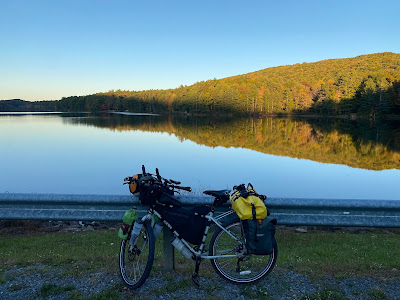
The Troll overlooking Lake Moomaw

There surely are plenty of flat spots in southwestern Virginia and southeastern West Virginia.


But it was the hills that my friend Dave Green and I spent the vast majority of our time and energy on during a cycling tour there last week, and some of those hills were so long and steep that it was faster to walk than ride them.


During the second day of our 360-mile lap around the Adventure Cycling Association’s Allegheny Mountains Loop, the steep gravel roads were made more challenging by a drenching morning rain.


The following day, some of the roads were so steep that I often found myself unable to pedal faster than 2.2 miles per hour. I was able to push my bike uphill just as fast or faster on foot, and did so on a few occasions.


The only part of the loop where we didn’t have to climb hills for at least a significant part of the day was on the 78-mile Greenbrier River Trail between Cass and North Caldwell, both in WV.


This very well-maintained, gravel-surfaced rails-to-trails path, which offers several free campsites along its way, runs ever-so-slightly downhill north-to-south, and thankfully that’s the direction we were pedaling. Several of the campsites have potable water, vault toilets and wooden shelters.


The Greenbrier River trail was the only section of the loop where we encountered other touring cyclists, and these groups were mostly made up of fellow seniors.


Dave and I both used Surly touring bikes for this tour.


Dave rode his milk-crate-equipped Long Haul Trucker with front panniers. I rode my Troll. I used a frame pack and Ortlieb Gravel Pack panniers to carry my food and gear. We both used two-inch-wide Schwalbe tires.


Dave at Moncove Lake

We are happy to report that we experienced no major mechanical issues during the tour, though it appeared that Dave may have developed a slow leak in his rear tire during the ride’s final days.


The temperatures during the tour ranged from a daytime high in the mid-80’s on day 1 to a low in the mid-30’s on the morning of day 5. The afternoon temps were usually in the 60s and 70s. 


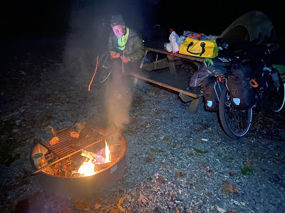
We camped on each of the seven nights we were out on the loop but only had to pay for three campsites.


Two nights we stayed in free sites along the Greenbrier River, and on the remaining two nights we camped in free informal sites on forest service property.


In the two public campgrounds we paid to stay at—Moncove Lake State Park in West Virginia and White Rocks Campground in Virginia—we were the only campers in the tent sites.


We packed most of our own food for the tour, but dined in several restaurants along the way, including Cheese N Things, a delightful Amish bakery/deli in Gap Mills, WV, the Swinging Bridge in Paint Bank, VA, the Last Run in Cass, WV, a Subway in the full-service town of Marlinton WV, and in the elegant dining room at the remote Mountain Lake Lodge near Newport VA.


One of the Mountain Lake Lodge’s claims to fame is that it was the site for some of the scenes from Dirty Dancing, the 1987 hit film starring Jennifer Grey and Patrick Swayze.


L-r, Dave, Doug, Mountain Lake Lodge

Most of the ACA loop’s roads were remote and very lightly trafficked. But there were a few poorly-shouldered exceptions, so we were glad our bikes were equipped with flashing taillights.


If you ride this loop, it would be best to have a low gear on your bike, because you will need to climb more than 20,000 feet, often on steep gravel, before you reach the finish line.


Also be sure to download your map to your navigation device before you leave home because cell service is not available on many of the more remote sections of the route, and many critical turns are unsigned.


We brought the ACA’s paper maps of the route along for backup.


Also be sure to pack a reliable filter or other purification technology because potable water sources can be few and far between.


Among the tour’s highlights for me were our wildlife sightings, which included a black bear, a pair of river otters, dozens of white-tailed deer and hundreds of wooly bugger caterpillars.


We also had a particularly memorable encounter on day 6 with a German Shepherd, which apparently had not read the memo about dogs being man’s best friend.


Special thanks to Dave’s friend Ed Cook, who let me park my van at his Blacksburg VA house while we were out on the tour. Ed and his wife Jerri also hosted a pizza party for us when we arrived back in town a week later.


For more photos and trip details, please see Allegheny Mountains Loop, Day 1.


R-l: Doug, Ed Cook, Jerri, Hokie fan friends


Colorado Trail

Snowy morning at Baldy Lake After 353.1 miles, more than 65,000 feet of climbing, and a week of hard frosts, hail, sleet and even a bit of s...